|
|
| Air Quality in the New Forest |
New Forest District Council carries out monitoring of air pollution levels
at a number of locations throughout the district. This monitoring is part of an ongoing programme of
review and assessment of air quality in all parts of the New Forest and its surrounds.
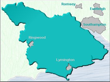
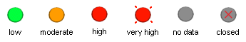
The map to the left shows peak pollution levels as recorded by automatic continuous monitoring analysers.
These analysers give precise levels of a number of potentially harmful pollutants, including nitrogen dioxide (NO2), sulphur
dioxide (SO2) and fine particulate matter (PM10). You can find out more information on these sites and the pollution
levels recorded by them by clicking on their dots.
Alternatively, click on the images below to view other information such as air quality reports, historical pollution
graphs and statistics and general information about pollution and health. You can even download the monitoring data
or plot your own graphs:
|
|
|
|